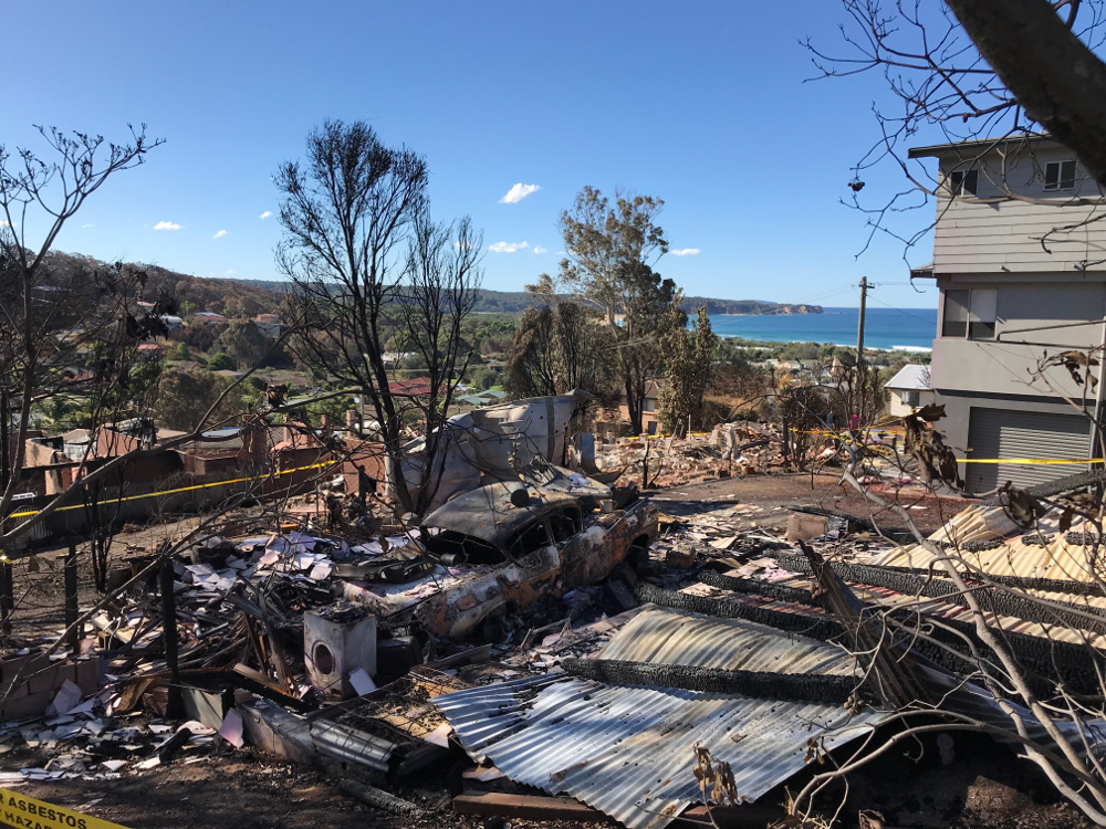
A BUSHFIRE and ember storm fanned by raging winds across the coastal escarpment brought devastation to the normally idyllic NSW south coast town of Tathra, destroying 65 houses and 35 caravans or cabins on Sunday 18 March.
Amid the devastation, the good news was that more than 800 houses were unscathed or saved, including all houses built requiring bushfire measures since building codes were amended after the 2009 Black Saturday bushfires in Victoria.
Raining embers
In the week following the bushfire, residents and firefighters gave their accounts of a fast moving fire that jumped the Bega River before ripping through bushland to the east of Tathra, and ‘raining’ embers and spotfires into the township.
“The embers were intense and literally raining down all over town starting up new spotfires everywhere,” according to one Tathra resident, Tom.
This type of ember attack and the pattern of house losses was unusual, according to Justin Leonard, leader of CSIRO’s Bushfire Urban Design and Post-Disaster Survey teams.
“In addition to house losses close to the fire front, we noted pockets of destruction much deeper into the township, some adjacent to the coast,” Leonard says. “We found chunks of charcoal as large as grapes and evidence of ember-ignited spotfires all across the town.”
“Spotfires have started up on decks, in gardens, coastal heath and even vegetation at the base of cliffs, taking out properties in some unexpected locations,” he says.
As with many Australian bushfires, the destruction seems indiscriminate, with some houses reduced to a pile of ash and twisted rubble while next door a house appears totally unscathed.
However, Leonard says there are many signs in the landscape, vegetation, building design and gardens that help understand what happened, why, and, most importantly, how it can be prevented in the future.
“Often the difference between house loss and survival comes down to a few features that repelled or let the fire take hold. For example, shrubs or mulch right up to the house, leaf build-up in gutters or ember-lodging points around timber eaves, timber window frames, decks or fences are common entry points.”
New house builds stand the test
CSIRO has a long history in research into bushfire behaviour and observing and recording the way that bushfires impact infrastructure and people. This research includes large-scale laboratory investigations of building performance under a range of fire exposure conditions.
CSIRO has supported surveys into every bushfire involving significant house loss since the 1983 Ash Wednesday fires in South Australia. These surveys have helped to inform building design and planning codes such as the NSW Planning for Bushfire Protection.
“The information gathered after the Tathra fire indicates a 100 per cent survival of new houses built after the introduction of the 2009 code,” says Leonard.
“New house survival is one of the positives emerging from Tathra and it’s encouraging because our work is absolutely aimed at improving future outcomes for property and people.”
Surveys after the fire provide valuable insights
Funded by the NSW RFS, the CSIRO team developed and first trialled a post-bushfire assessment apps at the Blue Mountains (Winmalee) bushfires of 2013. This has become the standard survey approach for the RFS.
At Tathra, in the week after the fire, RFS officers and the CSIRO team used the Bushfire House Surveyor app to collect more detailed, spatial (or geo-positioned) data about building design, local vegetation, surrounding terrain and the degree of damage, as well as accounts from people that help us to better understand what happened.
“We look at the houses, sheds, vehicles, vegetation, gardens and all the combustible elements,” says Leonard.
Casuarina needles and gum leaves that are scorched, bent and ‘frozen’, give away the direction of the fire and wind as it approached and impacted houses. Using the app, each of these clues is geo-positioned to help reconstruct a detailed picture.
“You can see all the leaves in the canopy are gone in some areas which means the fire was particularly intense and, with the prevailing wind and slope, could have been a major launch point for embers.”
On the day of the Tathra fires the Forest Fire Danger Index (based on temperatures and fuel moisture levels) was not as high as for many major fires, however the wind appeared to reach 80-90 kilometres an hour.
“One of the particular aims with the Tathra work is to understand how the unique terrain and various elements in the landscape contribute to this ferocious ember assault.”
“This is a very interesting landscape and the embers resulted in house loss further from the fire front than we typically see. There was ember spotting from the escarpment down to the beach and the embers led to house losses.”
“We want to answer questions of how and why embers travelled so far so that we can help improve the outcomes in similar situations in the future.”
Once CSIRO has completed the Tathra survey and report over the next few months it will be well placed to give further insights into how to protect towns that are surrounded by complex terrains, according to Leonard.
“The Tathra survey could potentially inform future strategies for building design and the extent of areas declared as bushfire prone. It could also help with targeting fuel reduction and vegetation management to protect more towns from the ravages of summer bushfires.”