Dr Andy Steven details the impressive technology CSIRO is using to lead the way in oceans and coasts observations and monitoring research.
Share
By
Melissa Lyne ,
Melissa Lyne
18 December 20186 min read
MUCH about the water surrounding our lands remains a mystery. Whether it’s the oceans, the shallows, or the seas in between, exploring and understanding man’s fickle friend comes with a unique set of challenges.
In the quest to tell the tales of these waters, sure, there's some desk time, but CSIRO researchers and staff are also exploring some of the most remote seascapes in Australia. They lug almost a tonne of tech at a time in and out of island waters off the coast, they program and deploy self-navigating robots that cruise the waves for months across vast oceans, and they board ships that are sent to explore the deepest (and unmapped) parts of Earth.
These waters are crucial for life. The oceans are a key driver of climate, and the marine food web sustains the existence of many land-based species, including humans.
In recent years, a series of El Niño and La Niña events led to two back-to-back bleaching events, killing 50 percent of the Great Barrier Reef’s corals. A marine heatwave killed parts of Western Australia’s kelp forests in 2011, while in 2015 the Gulf of Carpentaria suffered a large loss of mangroves. Further afield in Indonesia, macroalgae retreated to deeper, colder waters, which meant the artisanal communities harvesting this resource had to dive deeper to find what they were looking for. This often led to death or injury.
Long-term data on our oceans and coasts reveals what’s changing, and what this means for the future.
“We need to measure our waters not just across space, but across habitats, and in time scales from minutes to years,” says Dr Andy Steven, Coasts Research Director at CSIRO.
“The ocean is dynamic, and its many environments are challenging,” he adds. “They range from extreme environments such as Antarctica, to the warm waters of the tropics, and across features such as reefs, underwater mountains, and hydrothermal vents.”
“The main difficulty in navigating and observing the deeper ocean is that it’s very large, dangerous, and, well, deep. Along coasts the water can be dirty and turbid, so much so that you can’t see or dive.”
“We need to find better ways of sampling from the surface to the depths, from inshore to offshore, and all while using novel sensors to measure physical, chemical and ecological conditions.”
A new era
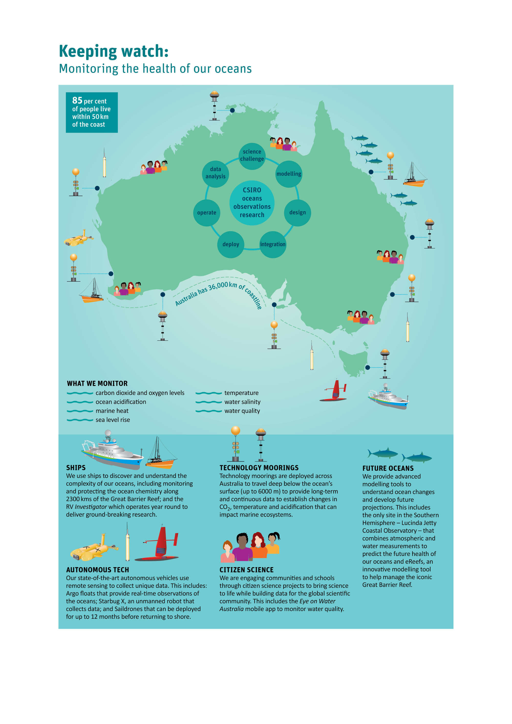
CSIRO boasts a portfolio of state-of-the-art observation technology, which is leading efforts in oceans and coasts observations and monitoring research.
The extensive tools have the potential to transform the ability of national, state and local agencies to observe and gather data on Australasian waters. The data can then inform better decision-making and management around the environment, industry, fisheries, tourism and communities.
Steven explains that some state agencies collect samples only once a month from a few coastal sites. This method can be under-representative of what’s really going on. Big events such as floods, and the lead-up to these events, can be missed altogether.
“This is a problem as observations are crucial to how we do our science,” says Steven.
“We need to harmonise the data collected by different agencies to tell a more complete story of what’s happening.”
Automating processes
Australia has 36,000 km of continental coastline. This extends from tropical coral reefs and mangroves in the northern latitudes to peri-urban estuaries and rocky reefs in southern Australia.
These habitats are variously monitored to provide information on a number of issues, including the effects of land-based nutrient or sediment discharge. There are also hard to measure issues such as ocean acidification. And then there are unpredictable events such as marine heatwaves, and other extreme climate events.
“To take more efficient and effective observations we’ve developed sensors that take measurements continuously,” says Steven. “This technology can be deployed autonomously and capitalise on existing shared infrastructure. The technological moorings we operate with IMOS are a good example of this.”
Sampling is a challenge not just across time, but space too. Australia holds the third largest marine estate in the world. Steven says there are two approaches to sampling through space, and both use automated technology.
The first is earth observations, via satellites.
“The second approach is to use ROVS—remotely operated vehicles—and gliders. CSIRO have developed platforms, such as the Starbug X, that allow sampling in 3D space.”
The right platforms
Starbug X is an autonomous underwater vehicle with active propulsion that carries a range of different sensors while self-navigating waters that are inaccessible or dangerous for humans.
“We also work with other companies and their platforms, such as ships, to carry instruments and complete repeat transects that give us high-resolution parameters. For example we instrument a vessel that transits along the Great Barrier Reef and takes measurements of carbonate parameters. These measurements tell us about the vulnerability of the reef to ocean acidification.”
“In more extreme environments, such as Antarctica or along the Kimberley coast, we use remotely deployed cameras or acoustic tags to count and track the movements of birds, sharks, whales and more.”
Steven says there are several autonomous surface vessels (ASVs) currently transforming our ability to collect observations. These can travel long distances, across many oceans, surveying along the way. And they are relatively cheap to run.
“But, we still need the right sensors for the right things,” he adds.
“And we need to move to systems that can better anticipate change, rather than reacting to what’s already happening.”
Sentinel indicators
CSIRO deploys a range of different sensors: optical, acoustic, ecological and genomic.
Optical devices, such as cameras, can relay images of events such as coral bleaching in real time. Thermal imaging is another useful technology that can indicate the metabolic energy or condition of an organism.
Acoustic methods measure environmental factors such as suspended sediment, or the movement of different plankton communities up and down the water column. These methods are particularly useful in murky coastal environments.
However, Steven says anticipating change requires better measurements of ecological and genomic factors.
“Ecological indicators include microbial communities, which have the potential to be a sentinel indicator. A particular taxa can tell us that something is happening, but their turnover is fast—days to hours.”
“We need to develop sentinel indicators of change, and create better metrics, so that we can monitor events before they happen.”
Monitoring the future
CSIRO uses a modelling framework, which focuses the use of information to proactive, rather than reactive.
“We use a framework to collect observations across space and time to better inform the validation and calibration of models,” says Steven. “An example of this is assimilating data to provide a two to three-day forecast of hydrodynamic conditions. Are we going to see a flood? What will it do to the Great Barrier Reef? Will there be an algal bloom? We can then share this information with management agencies and the general public. This kind of information is helpful in both prevention and mitigation.”
And, efficient and effective monitoring doesn’t stop once you’ve collected and processed the data. “Good communication and decision-making around the data is crucial,” says Steven.
Looking ahead
Steven believes creating better environmental, ecological, social and economical metrics, using the right technology to address challenges, and working collaboratively will inspire a more effective and efficient use of data.
CSIRO’s groundbreaking knowledge is already helping manage coastal resources and assets across the Indian Ocean, South East Asia, Latin America and the Pacific.
“We collaborate with industry, government and a global network of scientists to ensure a sustainable future for resources, fisheries, tourism and marine ecosystems, while informing future policy,” says Steven.
“We work globally, but apply that back for national benefit. Our work in Chile’s aquaculture industry, for example, is now being used in Tasmania’s aquaculture industry.”
Reflecting on the CSIRO mandate, Steven says, “Our fundamental mission is providing the science that addresses current and emerging issues. Often we are identifying what those issues are.”
“Our changing oceans and coasts have wide-ranging impacts,” he continues. “And that’s why integrated observations, monitoring, modelling and research is important.”
“We need to see what’s already happened, track what’s happening now, and anticipate the changes ahead in order to secure our future.”
Contact us
Find out how we can help you and your business. Get in touch using the form below and our experts will get in contact soon!
CSIRO will handle your personal information in accordance with the Privacy Act 1988 (Cth) and our Privacy Policy.
Thank you
We have received your enquiry and will reply soon.
We're Sorry
The contact form is currently unavailable. Please try again later. If this problem persists, please call us with your enquiry on 1300 363 400 or +61 3 9545 2176. We are available from 9.00 am to 4.00 pm AEST Monday - Friday.