THE cattleman’s battered hat and dusty boots still hold largely true as the image of agriculture in northern Australia.
Cattle remain by far the largest agricultural industry across the tropical north. A long way ahead of sugar cane and bananas, next in the top 10 of produce from northern Australia according to the latest available figures.
The north’s climate and soils could support a wide range of agriculture, aquaculture and horticulture, and potentially more integrated, efficient and higher yielding farming systems.
But the potential for further development across the region has lacked the detailed data required to confidently make those decisions.
The Northern Australia Water Resource Assessment, just completed by CSIRO for the Australian government as part of the Agricultural Competitiveness White Paper, delivers this region-wide, fine-scale data not previously available.
Precision data for future decisions
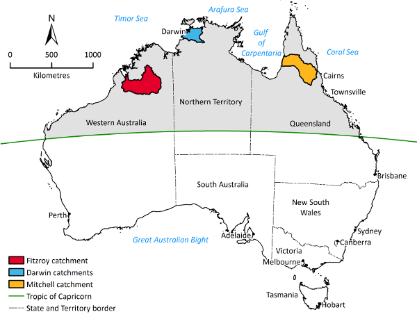
The Assessment focused on three study areas: the Fitzroy River catchment in Western Australia; the Finniss, Adelaide, Mary and Wildman river catchments in the Northern Territory; and the Mitchell River catchment in Queensland.
CSIRO has previously worked at a sub-continental scale across northern Australia to estimate how much soil and water is available that could support further development. We calculated that there are more than 16m ha of soil that could be irrigated in the northern draining catchments of northern Australia but there’s only enough rainfall which you can capture for about 1.5 million hectares of irrigated agriculture. What these figures don’t show is the complex combination of factors which might determine the real scale and nature of future development opportunities.
What was needed next was to drill down to the scale where decisions are made, so at a catchment scale you can see what is possible to farm and what water is available.
Our reports and the data produced as part of the Assessment can help identify the locations with the most potential.
There’s so much water in the wet, what can be so hard?
To understand the challenge of northern Australia, you need to understand the inherent contradiction.
It’s about water, and while about 2 million gigalitres of rain falls in Australia’s tropical north each year, mostly in the wet, on average 90 per cent evaporates.
And some of that water comes in flood – fast.
Development will depend on reliable water resources. Conditions vary across the catchment areas.
In some cases, it might be possible to pump water directly from the river source or by using groundwater from aquifers. That’s the story in the Fitzroy catchment in Western Australia.
Water can be pumped from the river or taken from the groundwater sources below – but knowing how much water can be taken before affecting the water levels in the unseen aquifers and the persistent waterholes fed by groundwater, is critical.
In other locations, how best to capture water from rains and floods becomes the question: How can water be conceivably stored and stored nearest to those areas most suitable for irrigation?
This part of the Assessment has required complex and integrated work from hydrologists specialising in surface water, as well as researchers able to draw on remote sensing satellite data to establish evaporation rates from water sources and transpiration from vegetation, and modellers who have examined stream flow in the rivers.
In the catchments around Darwin, it will likely be a combination of groundwater, instream dams and offstream, on-farm ring tanks (sometimes called turkeys’ nests).
In the Mitchell River catchment in Queensland the most likely pathway to development is with surface water storage. The Assessment identified a number of potential sites for prefeasibility analysis.
Discussion on potential development hinges on more than water.
Other factors which all come into play include:
- Logistics and transport costs, one of the greatest imposts in this remote landscape
- Market demand, there’s no point growing a crop no one wants or that doesn’t deliver the returns necessary to cover investment
- Cost and time taken for approvals
- Potential environmental impact from development
- Indigenous expectations.
What also makes this Assessment novel and valuable is the breadth of disciplines applied to the investigation. The Assessment was organised into activity groups which covered: climate; land suitability; surface water hydrology; groundwater hydrology; agriculture and aquaculture viability; water storage; socio-economics; indigenous water values, rights and development aspirations; and aquatic and marine ecology.
The north is diverse, but needs to diversify
The Assessment investigated a vast area close to 200,000 km² - almost the size of the state of Victoria.
While currently most of the value of agriculture comes from the extensive grazing of cattle, there is potential to look beyond cattle – while at the same time potentially making the cattle industry more productive.
Through a combination of extensive field studies and desktop analysis, the Assessment investigated land suitability to determine the amount, distribution and location of soil potentially suitable for irrigation and/or aquaculture.
There are a couple of messages from the Assessment when landscape suitability outcomes are tied together with water availability and also economic viability:
- Double cropping can increase revenue from each hectare developed but isn’t currently used in the region so there is little experience from which farmers can learn.
- Diversification is a way to improve productivity, particularly in the cattle industry where on-farm forage production could increase weight, and value, of livestock without necessarily increasing the overall number of stock.
- Rethinking the scale of irrigated agriculture. In some cases it will be multiple, smaller irrigated developments rather than large-scale. This brings the added advantage of reducing the initial cost and therefore the risk of new development.
Diverse interests at stake
There are many and diverse stakeholders in northern Australia, from investors overseas to directors in Sydney boardrooms; from pastoral lease holders to owners of small holdings; Traditional Owners; local communities; regulators; local and state governments; industry groups and environmental interest groups.
The Assessment engaged Indigenous people in the catchments to better understand their perspectives on development. They have water values, rights and development objectives. Many have business development objectives designed to create opportunities for existing residential populations and to aid the resettlement and return of people currently living elsewhere. Understanding how diverse perspectives interact will be crucial in building and maintaining ongoing social license to operate for future water and agricultural developments.
And while irrigated agriculture might, at the upper limit, occupy 3 per cent of the area assessed, it would result in changes to river flow volumes and patterns. What that might mean for the environment would necessarily be part of any more detailed feasibility studies. Again, social licence to operate demands consideration of environmental impact.
Bottom line – learning to play the long game
Northern Australia is still a frontier. There is a uniqueness about the opportunity – Australia’s reputation for “clean and green”; our market access and proximity to market; coupled with the opportunity to develop new water and land resources.
The work done in this Assessment highlights that there’s no single barrier to development, it is a complex combination of factors that need to be considered.
CSIRO’s role was not to prescribe or advocate for particular development. Rather, this work points to some of the most likely options which warrant further investigation for potential investment.
This is about better information, at finer scale, and making that available in as ready-to-use a form as possible, at the catchment scale for all interests.
The work required strong collaboration with multiple jurisdictions and agencies; an ambitious multidisciplinary science effort and, in some cases, development of new scientific methods to assess such large areas quickly.
The result is publicly available data for all to share for an informed discussion on what is possible, what is desirable and what is achievable. The web application, NAWRA-explorer, provides that data and will be continually updated meaning the outcomes of the Assessment have a long shelf life, knowing that these significant decisions will take some to make.
Dr Chris Chilcott, research leader, Northern Australian Development, CSIRO.
For more detail on the findings by catchment and also about the extensive Indigenous engagement conducted as part of the Assessment in all three catchments, please read on in this issue of ECOS.